This is just one of a series of aerial photos taken of the estate as roads were being laid out and construction beginning on ‘New Nunsthorpe’. These pictures taken on the 10th of May 1950, now reside in the collections of Historic England, who have now made their whole collection available online. To see this and other images of the estate taken during flight AFL4142, click the photo below – and for more local images from that same flight and others from across the whole country from the 1920s to the 50s, search the site a little further – it’s free!
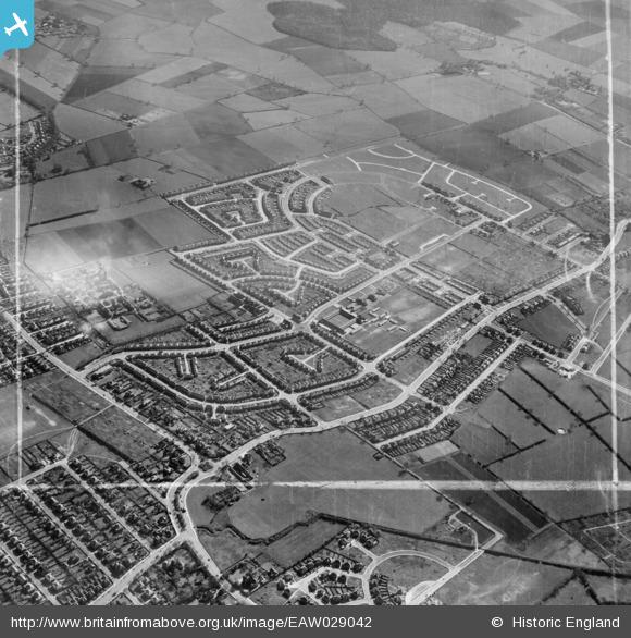
On the photographs you can see how very little building there was along Laceby Road, Milton Road looking completed, you can see the school and the various huts and prefabricated classrooms to the field behind, building at the east end of Crosby Road is complete, the prefabs in place along Walmsgate and along the east side of Winchester Ave with buildings established on the west end of Winchester and Orby Grove too.
Whilst marked out ready for laying in services prior to building are the footprints of Firsby Crescent, Amcotts, Withern and Scawby Roads, Crowle and Stainton Drives – all clearly marked, awaiting building. Langton Drive and Wooten Road are little more than flat patches in the grass. Also notice that there seems to be five or six cars on the whole photograph – the roads completely empty! A fascinating snapshot.
In an even older survey of Grimsby from May 1925, pictures of People’s Park show the fledging Garden City just in the distance, also available on Historic England’s Britain from the Air website.


You don’t realise how close the estate is to People’s Park – seemed a million miles away! You can see the Nuns farm on that older picture too. What are the buildings to the right of it, on Bargate? Is that the ruins of the actual Nunery?
LikeLike
Are you confusing Bargate with Welholme Ave? I think that’s St.Martin’s School (or what’s now St.Martins School – what was it then?) Bargate is just out of sight behind it.
LikeLike